
Drone technology is fast becoming a vital part of how we manage and maintain our electricity network. Given the scale and complexity of our network across regional, rural and remote New South Wales, drone technology offers a smart, safe way to inspect the network, mitigate bushfire risk and respond to major weather events.
By increasing our reliance on drones, we’re improving the speed and accuracy of inspections, reducing risks for our crews, and enhancing our ability to deliver a safe and reliable network for our communities.
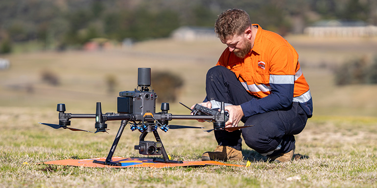
How we use drones
Drones are a key tool in our asset management program. As we continue to scale up its use across the organisation, drones are helping us inspect assets more safely, efficiently, and cost-effectively than traditional ground-based or aerial methods.
We use drones to:
- Conduct routine inspections of the electricity network
- Assess damage and prioritise repairs after floods, storms or bushfires
- Monitor vegetation encroachment to reduce bushfire risk
- Capture high-resolution imagery and data to support digital mapping and the creation of a network digital twin
- Support planning and design for network upgrades.
Our drone fleet technology
Currently, we operate a fleet of more than 300 drones, ranging from 250g to 25kg, supported by specialised equipment such as high-resolution and thermal cameras, LiDAR sensors and other tools to capture precise data for inspections, maintenance, and network planning. Our drones are identified by orange Essential Energy stickers and logo and are working near powerlines.
Drone safety, privacy and compliance
All drone operations are conducted in accordance with Civil Aviation Safety Authority (CASA) rules and regulations, following strict safety and privacy protocols. These operations are solely for the inspection of Essential Energy’s infrastructure and do not involve surveillance or the collection of personal data.
We hold a Remotely Piloted Aircraft Operator’s Certificate (ReOC), which allows our qualified remote pilots to conduct commercial operations under CASA’s aviation standards. This allows for drone operations to be completed outside the standard operating conditions including:
- Flying in controlled airspace
- Operating beyond visual line of sight (BVLOS)
- Conducting flights over or near people
- Performing inspections at night.
We also have CASA-accredited drone operators who fly in accordance with the standard operating conditions and our strict internal safety and training requirements.
Asset inspections
As part of our commitment to delivering reliable power to communities across regional, rural and remote New South Wales, we conduct regular inspections of our poles, wires and other network assets. Using drones as part of these inspections provides a safe and efficient way for our crews to check for any issues that may cause an unexpected power outage.
Drone technology is used for inspections across the entire network, from densely built-up urban areas to the more expansive rural regions, helping our crews access hard-to-reach locations and complete inspections faster, with minimal disruption to the community.
Pre-Summer Bushfire (PSBI) and Sub Transmission inspection programs
A critical component of our network management is our Pre-Summer Bushfire Inspection (PSBI) and Sub Transmission inspection programs. Both programs increasingly rely on drone technology to safely and efficiently inspect infrastructure, especially in remote or difficult-to-access areas.
The PSBI program involves targeted inspections of electricity assets in high bushfire-risk areas ahead of summer. These inspections help us identify faults, vegetation encroachment, or other hazards that could pose a risk during the bushfire season.
The Sub Transmission inspection program focuses on approximately 2,500 sub transmission poles in North Western NSW. Using drones and helicopters, we assess asset condition and vegetation risks to ensure the resilience of high-voltage feeders.
For more details on inspection schedules and customer notifications, visit our Aerial Inspections page.
Major flood, fire and storm response
Drones play a critical role in our response to major weather events, enabling us to quickly and safely assess damage to the electricity network following storms, floods, or bushfires. By providing rapid aerial inspections, drones help identify hazards, prioritise repairs, and guide crews to areas that may be difficult or unsafe to access. This ensures a faster, safer, and more efficient restoration of power for our communities.
The digital twin
We also use drones fitted with LiDAR technology to support the creation of a digital twin of our network. These detailed 3D models provide highly accurate survey data that supports design and engineering, helping us plan and deliver work more efficiently. By using this technology, we improve safety, reduce costs, and ensure a more reliable electricity network for our communities.


